“To plug-in or not to plug-in?” That is the question.
Fluvial geomorphology is the science of interpreting river forms, processes, and evolution. Traditionally, geomorphologists made extensive use of maps, aerial photographs, and notebooks to undertake field analyses. Today, the toolbox available to contemporary geomorphologists includes high resolution satellite imagery, unmanned aerial vehicles (UAVs), and on-ground scanners, sensors and a range of automated measurement and monitoring techniques.
Enhanced data availability is transforming how rivers are viewed, in dimensions and levels of detail like never before. However, to gain a rich interpretation of river forms, processes, and evolution requires that analyses ask the right questions, rather than being overwhelmed by technical prowess. This calls for the effective use of conventional geomorphic insights and principles, carefully tailored through a conceptual structure/framework and a sequence of activities/steps and tools/workflows that take meaning from big-data, and checking the outputs and findings in the field.
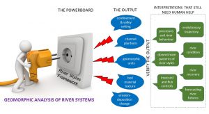
In this WIREs Water review, the authors appraise the effectiveness with which emerging technologies and tools can (or cannot) be used to semi-automate the geomorphic analysis of rivers. They discuss what tools are already available to plug into this process, what cannot yet be done, and where specific human decisions are still needed. They demonstrate how Stage 1 of the widely used River Styles Framework (which entails identification and interpretation of river character and behavior, patterns and controls) can be used as a “powerboard” into which available, developing, and future semi-automated tools and workflows can be plugged—or unplugged.
They appraise the role of human decision-making in conducting expert–manual analyses and interpretations or rivers, concluding that humans are not yet redundant. Humans are still needed to choose the right tools for the job, interrogate and validate output(s), make geomorphic interpretations of rivers, and guide management options.
Genuine integration of big-data analytics, remote-sensing based tools for semi-automated river analysis and expert–manual interpretations (including field insights) is required to fully exploit emerging computational and remote sensing technologies, thereby advancing the understanding of river morphodynamics and evolutionary traits, and enhancing the standards of practice in river science and management.