River floodplains provide valuable physical and ecosystem functions—such as flood attenuation, groundwater recharge, nutrient and sediment flux, and critical habitat—that benefit human populations and many terrestrial and aquatic species. Floodplains are also some of the most desirable, modified, and impacted habitats by humans globally.
Construction of flow control structures (such as dams and levees) as well as agricultural, industrial, and urban development have simplified river networks and disrupted connections between rivers and their floodplains. Losses of floodplain habitats have been identified as one of the major factors for the listing of many salmonids and other fish as threatened and endangered under the U.S. Endangered Species Act.
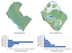
A example of a topographic survey output showing water depth distribution at bankfull flow before and after floodplain restoration for Catherine Creek, Oregon. Topographic data courtesy of Bonneville Power Administration and Confederated Tribes of the Umatilla Indian Reservation.
Large efforts are underway in North America, Europe, Australia, and elsewhere to restore floodplain habitats, not only to increase fish and aquatic biota but to restore ecological diversity.
As the scale, number, and complexity of floodplain restoration projects has increased (and associated investments in these projects), the need for rigorous monitoring and evaluation of effectiveness are needed to guide future floodplain restoration efforts. Moreover, technological advances in remote sensing, genetics, and fish marking have been evolving rapidly and there is need to update guidance on the best methods for monitoring physical and biological response to floodplain restoration.
In a new WIREs Water review, the authors synthesized published papers evaluating floodplain restoration effectiveness and new and evolving techniques for monitoring changes in floodplain habitat and biota to help guide future monitoring efforts.
Their review and synthesis indicated that many traditional approaches for monitoring are still appropriate for monitoring small floodplain restoration projects. However, advances in remote sensing in the last decade (e.g., Lidar, satellite imagery, drones with a broad range imagery capabilities) and new and evolving technologies are likely to be more cost-effective and efficient methods for monitoring large rivers and large floodplain restoration projects. There are also several methods, evolving techniques, and metrics that have been recently developed and applied to European rivers and floodplains that show great promise (e.g., dragonfly indices of integrity, morphological quality index), but additional research or testing are needed in other regions.
While the ideal methods for monitoring floodplain restoration projects will largely depend upon the specific monitoring questions and the project or projects being evaluated, it is likely that a combination of traditional field-based approaches coupled with remote sensing and new methods for measuring biota and physical habitat, will be the most informative and cost effective.