Hydrologists and geochemists study the circulation of water and solutes through the landscape, and a convenient unit for such studies is the catchment. Catchments (or watersheds) are topographically enclosed areas over which the precipitation (minus evaporation and plant transpiration) converges into the streams and eventually exits at the stream outlet.
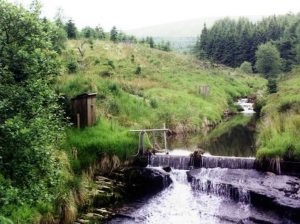
The Tanllwyth stream at the Plynlimon research catchment in Wales. Image credit: James Kirchner / ETH Zurich.
The image above shows the stream outlet of the Plynlimon catchment in Wales, the topographic boundaries of which are defined by the hills in the background. Throughout the catchment, water comes into contact with soils, rocks, plants, and animal life. In doing so, it dissolves minerals, gases, and organic compounds, washing them into the streams. At the stream outlet, the flow rate can be “gaged” (gage shown in the image), and the chemical constituents being carried in the stream water analyzed to estimate the rate of geochemical processes in the surrounding area, such as rock weathering, carbon export, and nutrient loss from the catchment.
Catchments have therefore been a powerful tool in studying terrestrial processes because it is straightforward to delineate the catchment boundary from topographic data, and we can learn a great deal from “reading” the stream physics and chemistry.
While a lot can be learned, these inquiries are limited because they rely on the assumption that a catchment does not lose water underground. The flow of groundwater does not always follow surface topography, but rather reflects the easiest path through permeable materials. Such geologic structures do not always align with the topographic catchments. Since it is difficult to accurately observe what is happening below the surface, we have limited knowledge of the depth of permeable materials underneath a catchment and whether water can “leak” in the subsurface, undetected by the stream gages; e.g., if a catchment is situated on top of a highly permeable sedimentary rock formation that has an inclination (or dip), then groundwater could “leak out of” the catchment up-dip and that water can “leak into” another catchment down-dip.
In this Wires Water review, the author set to determine if catchment leakage is the norm and what determines the significance of leakage. Catchment studies that have documented leakage were reviewed and several factors to help determine if a given catchment could be leaky were proposed. Chief among them are regional geologic settings.
Although geologists and hydrogeologists study the subject carefully, their expertise has not intercepted those of catchment scientists. The two disciplines traditionally asked different questions, with hydrogeology focusing on the groundwater and catchment hydrology on stream-flow and flooding. They do, however, examine the different expressions of the same hydrologic system, because in nature, surface water and groundwater are connected, and a water molecule can change its identity many times before it reaches the ocean or returns to the atmosphere.